
Hey everyone! I'm finally back with some more canyon stories. You may have noticed I've been missing from this little blog for a while and that's because I've been editing about a million photos! Serious, I took waaay too many photos on this trip. Well, the good news is that I've finally sorted through all of them, but there are so many I'll have to break it up into a few more posts.

If you need a recap, you can find the Part 1 post here. We had our gear all set and had settled in for the night with bellies full of pizza. And we did one final run through our checklist:
 |
| source |
Check, check and check, however, we didn't sleep long because we were all packed up and headed for the Canyon Village by 3:30am to catch our shuttle. It was eaaaarly, but we were all to nervous/excited/giddy to be too sleepy by this point.

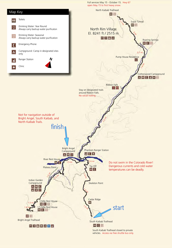
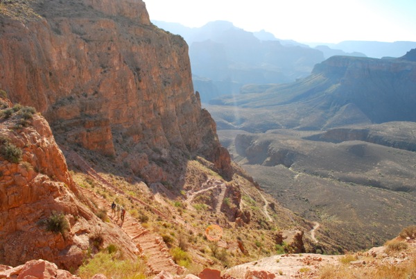
The day's hike was not an easy one. We took the South Kaibab Trail, starting at the trailhead and going all the way to Bright Angel Campground, for a total of 7 miles.
(shown by the blue arrows below)
(shown by the blue arrows below)
 |
| source |
 |
| source |
You might notice that little warning mentioning the fact that there is NO water on the South Kaibab Trail. And it is true - no faucet, no drinking fountain, not even a little spring to cool off in. The South Kaibab provides some of the most spectacular views of the canyon, but it is a difficult and dangerous trail since there is no water. And did I mention that it gets hot?
 |
| source |
Really hot. So, if you plan to hike the South Kaibab, you need to carry all of your water down with you, along with your food, clothes, sleeping bag etc. So although 7 miles doesn't sound too bad, when it's getting close to 100 degrees, you're in full sun, and you're carrying a 35 pound pack on your back, it can get a little tough. And then there's the elevation change. From the start of the trail to the bottom the canyon goes through a one mile elevation change.
(shown by the blue arrows below)
 |
| source |
The first few miles aren't bad. The temperature is still cool, and your legs are still fresh. But after a few miles, you Start. To. Feel. It.
But enough with the charts and graphs, already! On to the photos!
Once again, here is our lovely group: Me, Mick (my dad), Jake (my husband), Jeff and Jean (family friends), and Luke and Katie (my cousins). Notice how energized and clean we look - that will quickly change...

We hopped on the 4:00am shuttle at the Bright Angel Lodge and drove out to the Kaibab Trailhead. Since we started hiking around 4:20, we still needed our headlamps to see the trail (and to look really cool). Other than the light from my camera flash below, you can see that the trail is pretty dark.

A short distance down the trail, we came to Ooh Aah Point: the perfect place to catch a breath taking sunrise. And you guessed it - we "oohed" and "aahed".


From there, our trusty guide (my dad) lead us on down the Kaibab.


And then things got fun...


And hot...


...Really, really hot.


We stopped for water breaks wherever we could find shade, and fueled up on Gatorade and snacks. (As a side note, due to this trip, I have no desire to drink red Gatorade for at least a year. Or ever.)


By this point in the hike, we were about to the blue arrow below. We had to get aaaaall the way down to those green trees at the bottom, shown by the green arrow. Blue to Green arrow = a long-*ss way.


We made one final rest stop to grab a snack, drink water, and tape up blisters and (yes, that's duct tape Katie is wearing over her blister) onward we went. It was starting to get late in the morning and we needed to get to the bottom asap to beat the heat.

Not too much further down the trail, we came across these guys. If hiking isn't you thing, you can always take a mule (or even a raft).

I'm not sure why this guy was hanging out by himself, but he was pretty darn cool looking.
 |
| Sup. |

And we knew we were so close when we could finally see the suspension bridge that would take us to Phantom Ranch, our final destination. You can see a tiny strip of black going across the sliver of river showing below. That's the bridge that would take us to the "promise land".

We stopped for one last photo before we passed out from heatstroke/exhaustion and headed across the bridge.


We had finally made it to the bottom. Now just another mile to the campground...

So that's the first leg of our hike. I'll be sure to have more photos from the rest of our trip up shortly, so check back soon!
Have you ever hiked the South Kaibab? What are some of your favorite memories (besides making it to the bottom)? Leave a comment to share!

No comments:
Post a Comment